


")


Need a gift for an outer space lover at home? Do you want to inspire a love of the cosmos in a classroom?
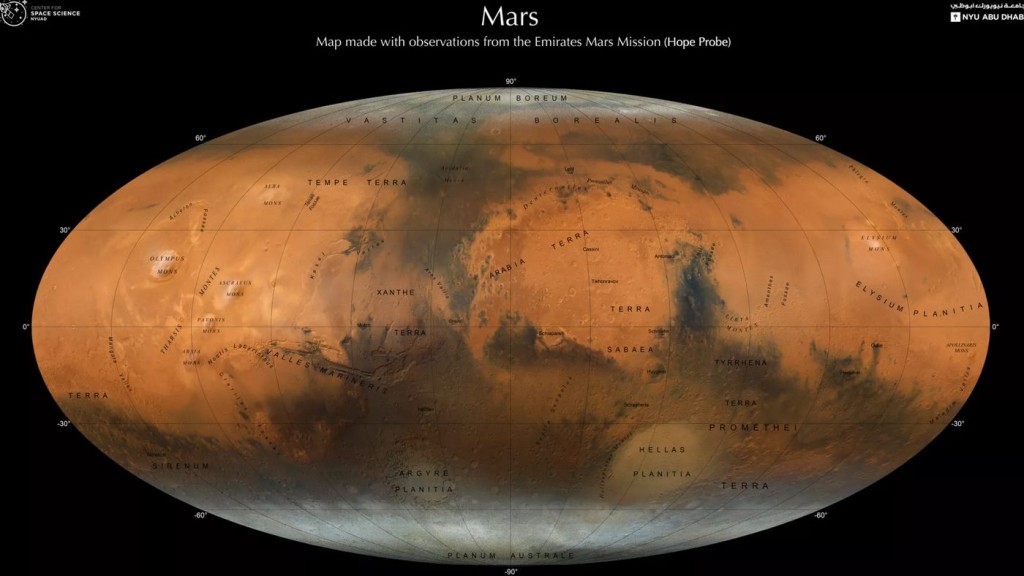
Thanks to the most successful space mission ever completed by a Middle East country, a new atlas of Mars is available for researchers based on 3,000 images stitched together.
It’s amazing to have an image of the second-best-researched planet in the solar system displayed in the same way we all picture our own world in our heads—it makes the idea of Mars as a neighbor so much more identifiable.
The atlas was created by a team from New York University Abu Dhabi (NYUAD) and the United Arab Emirates (UAE) Center for Space Science, and far from being merely a display piece for science classrooms, offers a lot of insight for senior scientists as well.
“We plan to make our map available to the entire planet, as part of the new and more advanced Atlas of Mars, which we have been working on, and will be available in both English and Arabic once published,” NYU Abu Dhabi (NYUAD) group leader and research scientist Dimitra Atri said in the statement.
“The hope is that this accessibility will make it a great tool for researchers, and also students to learn more about Mars, and showcase the possibilities that the space sector in the UAE can offer.”
The Emirates Mars orbiter Hope (Al-Mal) equipped with the Emirates Exploration Imager, launched in July 2020 from Japan, and the map thusly produced reveals the Red Planet in detail never before captured at this scale.
MORE SPACE STORIES: Hubble Sees a Possible Runaway Black Hole Creating a Trail of Stars
Every named and explored feature of Mars, such as Olympic Mons, the solar system’s largest volcano, is displayed on the atlas, as well as polar ice caps, extinct river, and lake systems with their deltas where NASA’s Perseverance rover has been exploring.
MORE MARTIAN NEWS: Fascinating Images Show ‘Winter Wonderland’ on Mars Captured by Reconnaissance Orbiter
“The Hope probe is helping researchers to create this global image of the planet due to its strategic position,” Atri said. “Hope circles Mars in an elliptical orbit that allows it to observe from much further away than any other spacecraft. This strategic position is helping researchers to create a global image of the planet.”
The map also reveals the history of asteroidal bombardment of the planet, giving a wide-angle view of the conditions in the early solar system. Scientists can use the pattern of asteroidal bombardment to estimate the density and patterns of debris back 3.5 billion years ago.
You can view all the maps within the atlas here on the NYUAD website
SHARE This Never-Before-Seen View Of The Red Planet With Your Friends…