


")


Declassified photos captured by United States spy satellites launched during the Cold War have revealed an archaeological treasure trove: hundreds of previously unknown Roman-era forts.
Corona and Hexagon were two satellite surveillance programs meant to support the Carter Doctrine of US dominance of the Middle and Near East, but now archaeologists are using their declassified aerial photos of landscapes long lost to map the presence and nature of the eastern border of the Roman Empire.
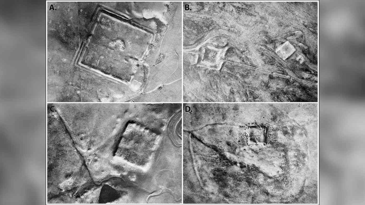
The research team from the Department of Anthropology, Dartmouth College, poured over the photographs and compared them to a map produced in 1934 by a Jesuit missionary named Father Antoine Poidebard, who was also an archaeologist.
His survey was the first to map the presence of Roman forts in the area from the sky, and it was a flawed yet monumental achievement that confirmed the existence of 116 Roman fortified structures that created the working theory that they represented a wall of men and forts to protect the eastern border.
Now however, the Hexagon and Corona photos are changing the narrative from one of security of the nation to the security of a dynamic and fluid border of trade routes and cultural interchange that the Romans relied on for import and export.
“Agriculture and urbanization have destroyed a lot of archaeological sites and features to a shocking degree,” Archaeologist Jesse Casana told CNN. “This old imagery allows us to see things that are often either obscured or no longer extant today.”
MORE ROMAN DISCOVERIES: Tiny Italian Town Dug Up an Extremely Rare Roman Temple while Trying to Build Supermarket
The forts were more or less simple to identify. The Roman soldier was a ferocious and disciplined warrior, but he had another special power: he was a talented and efficient construction worker. The building of standardized square forts of about 164 to 262 feet (50 to 80 meters) at regular intervals while on campaign proved across the long history of both the Republic and Imperial periods to be an invaluable strategy.
Poidebard’s map described the forts as making up a north-south line which looked to the Frenchman like a wall, but the satellite photos reveal those were more like the western garrisons of a fortified corridor with forts on either side of a massive area that stretched eastward all the way through Syria to the Tigris River in Iraq.
MORE MIDDLE EASTERN ARCHAEOLOGY: Stunning Ancient Artwork Found at Site Sacked by ISIS: Assyrian Depictions Not Seen For 2,600 Years–LOOK
The Corona and Hexagon photos revealed an additional 106 structures spanning approximately 116,000 square miles (300,000 square kilometers) from the Med to the Tigris.
Through this corridor would have moved valuable trade routes—indeed one of the Western termini of the Silk Road of the Han Dynasty.
Casana told CNN that it’s her reading of the archaeological litterature that even in places as developed and advanced as Rome, borders in this time period “were places of dynamic cultural exchange and movement of goods and ideas,” not barriers.
YOU MAY ALSO LIKE: Archaeologists Uncover ‘Complete Roman City’ From 1,800 Years Ago in Luxor–Including Pigeon Towers
After four-decades of American wars in this part of the world finally coming to something resembling an end, archaeologists like Casana might have opportunities in the near future to investigate some of these hundreds of sites, some of which may still have important details and artifacts to reveal.
The northern border fortifications of the Roman Empire are a UNESCO World Heritage Site jointly-managed across many countries. Could the eastern border be the same in the future?
SHARE This Amazing Discovery With Your Friends Who Love Rome…